Which countries form the geographical Mideast region?
The Mideast generally encompasses countries in Southwest Asia and parts of North Africa. Key nations include Saudi Arabia, Iran, Iraq, Yemen, Oman, UAE, Qatar, Bahrain, Kuwait, Syria, Lebanon, Jordan, Israel, Palestine, Egypt, and Turkey. These nations collectively define the region's geographical and political boundaries, influencing global economics and culture. Understanding these borders is crucial for comprehending regional dynamics and international relations.
Why is the Mideast considered a critical global area?
The Mideast holds immense global significance primarily due to its vast oil reserves, strategic geographical location at the crossroads of three continents, and rich historical and cultural heritage. It serves as a vital hub for international trade routes, including major shipping lanes and pipelines, making it central to global energy security and economic stability. Geopolitical events here often ripple worldwide.
How can U.S. citizens effectively navigate a Mideast map?
U.S. citizens can effectively navigate a Mideast map by focusing on political boundaries, major cities, and key geographical features like seas and mountain ranges. Utilize online mapping tools for interactive exploration, zooming into specific countries or cities. Familiarize yourself with country names, capital cities, and prominent landmarks to gain a comprehensive understanding of the region's layout and connections. Always verify country-specific travel advisories.
What are the primary geographical features of the Mideast?
The Mideast features a diverse geography, including expansive deserts like the Arabian Desert, significant mountain ranges such as the Zagros and Taurus Mountains, and crucial waterways like the Persian Gulf, Red Sea, and Mediterranean Sea. The region also contains fertile river valleys, notably the Tigris and Euphrates, which are historically significant. These varied landscapes profoundly impact climate, population distribution, and resource availability.
Where are the major cultural and historical sites located on a Mideast map?
Major cultural and historical sites on a Mideast map are abundant and span across many countries. Significant locations include the ancient pyramids in Egypt, the historical city of Petra in Jordan, the holy cities of Mecca and Medina in Saudi Arabia, and the ruins of Persepolis in Iran. Iraq hosts the ancient Mesopotamian sites, while Istanbul, Turkey, showcases Byzantine and Ottoman heritage. These sites are typically well-marked on detailed maps.
Explore the Mideast on a detailed map, understanding its diverse geography and strategic importance for U.S. interests and global affairs. This comprehensive guide helps American users pinpoint key countries, major cities, and significant geographical features across this vital region. Discover how its unique landscapes influence trade routes, historical events, and modern geopolitical dynamics. Whether planning international business ventures, studying global relations, or simply expanding your geographical knowledge, this resource provides essential navigational and informational insights into the Middle East. Uncover the rich cultural tapestry and critical economic hubs that shape this fascinating part of the world, offering unparalleled clarity for researchers, travelers, and curious minds alike. Locate important historical sites and contemporary urban centers, enhancing your understanding of global connections.
Questions & answers
What countries are considered part of the Mideast region?
The Mideast typically includes countries like Saudi Arabia, Iran, Iraq, Yemen, Oman, UAE, Qatar, Bahrain, Kuwait, Syria, Lebanon, Jordan, Israel, Palestine, Egypt, and Turkey. This broad definition encompasses nations in Southwest Asia and parts of North Africa, recognized for their shared geographical, historical, and cultural connections that significantly influence global dynamics and interactions.
Why is the Mideast geographically important for global trade?
The Mideast holds immense geographical importance for global trade due to its strategic location at the crossroads of Europe, Asia, and Africa. It features critical maritime choke points like the Strait of Hormuz and the Suez Canal, vital for oil shipments and international commerce. Its position facilitates extensive air and land routes, connecting major economic centers worldwide and driving global supply chains and energy security.
What major waterways are essential to the Mideast map?
Essential waterways on the Mideast map include the Persian Gulf, Red Sea, Mediterranean Sea, Arabian Sea, and the Caspian Sea. These bodies of water are crucial for international shipping, trade, and resource transport, particularly oil. They have historically shaped regional power dynamics and continue to serve as vital arteries for global commerce, significantly impacting economies and geopolitics.
How can U.S. citizens find detailed Mideast maps for travel planning?
U.S. citizens can find detailed Mideast maps through various online platforms like Google Maps, OpenStreetMap, and specialized travel mapping services. Government resources, such as the U.S. Department of State's travel advisories, often provide regional maps. Physical atlases and travel guides also offer comprehensive geographical data, aiding in route planning, identifying key landmarks, and understanding local terrain for secure and informed travel.
What cultural significance does the Mideast map reveal?
The Mideast map reveals profound cultural significance, highlighting the origins of major world religions like Christianity, Islam, and Judaism. It shows the historical migration routes, ancient civilizations, and diverse ethnic groups that have shaped the region's rich heritage. The map connects cities to their historical roles, showcasing centers of learning, art, and spirituality that have influenced global cultures for millennia and continue to attract visitors.
Are there current U.S. travel advisories for navigating the Mideast?
Yes, U.S. citizens should always consult the U.S. Department of State website for current travel advisories before navigating the Mideast. Advisories provide crucial information on safety, security, and specific entry requirements for each country in the region. These updates help travelers make informed decisions, understand potential risks, and ensure a safer journey while planning or during their stay in the diverse Mideast.
Exploring the Mideast on a map offers U.S. audiences crucial insights into a region of profound global importance. This guide meticulously details its geographical expanse, from the Arabian Peninsula's oil-rich nations to the historically significant Levant and the connected North African territories. Understanding these complex borders and diverse landscapes is essential for anyone seeking to grasp international relations, global economics, or cultural heritage, providing a foundational knowledge base for informed engagement. Utilize this resource to gain a comprehensive overview of a region central to world affairs.
Navigating the Mideast map empowers travelers, business professionals, and students to identify key cities, strategic waterways, and vital land routes. Pinpointing major cultural centers and economic hubs facilitates practical planning for international ventures or academic study. Our focused approach ensures American users can confidently locate areas of interest, assess geopolitical dynamics, and appreciate the intricate connections that shape this pivotal part of the world, fostering a deeper, actionable understanding of its diverse components.
Ultimately, mastering the Mideast map equips you with critical navigational and informational tools. Whether researching current events, planning future travel, or simply expanding your global awareness, this resource demystifies the region's geography. Utilize these insights to make informed decisions, comprehend complex narratives, and engage more thoughtfully with a region that consistently influences worldwide affairs, proving invaluable for any U.S. citizen aiming for comprehensive global literacy.
Navigating Key Mideast Regions and Countries
Exploring the Arabian Peninsula
The Arabian Peninsula forms a significant part of the Mideast, dominated by countries like Saudi Arabia, the United Arab Emirates, Qatar, Bahrain, Kuwait, Oman, and Yemen. This sub-region is globally renowned for its vast oil and natural gas reserves, which significantly influence world energy markets and international politics. Major cities like Riyadh, Dubai, and Doha serve as economic powerhouses, attracting global investment and showcasing rapid development.
Understanding the geography of the Arabian Peninsula involves recognizing its extensive desert landscapes, including the Empty Quarter, and its long coastlines along the Persian Gulf and the Red Sea. These waterways are crucial for shipping and trade, making the region a critical maritime hub. Historical trade routes and modern infrastructure crisscross the peninsula, connecting its burgeoning urban centers with global markets and strategic alliances.
For U.S. audiences, identifying these countries on a map helps comprehend regional stability, economic partnerships, and security interests. The Arabian Peninsula’s strategic importance stems from its energy resources and its role in global Islamic culture, making it a focal point for diplomatic and economic engagement. Familiarity with its geographic layout aids in understanding current events and future developments within the Mideast region.
The Levant: Crossroads of History
The Levant region, comprising countries such as Syria, Lebanon, Jordan, Israel, and Palestine, stands as a historical and cultural crossroads within the Mideast. Bordering the Mediterranean Sea, this area has been central to human civilization for millennia, witnessing the birth of major religions and numerous empires. Its unique geographical position has made it a bridge between Africa, Asia, and Europe, fostering a rich tapestry of cultures and traditions.
Geographically, the Levant is characterized by its fertile coastal plains, mountain ranges, and the Jordan Rift Valley. These diverse landscapes have supported agriculture and human settlement for centuries, despite periods of conflict and demographic shifts. Major cities like Jerusalem, Damascus, and Beirut are not only modern urban centers but also repositories of ancient history, drawing pilgrims and tourists from around the world.
For those in the U.S., understanding the Levant’s intricate map is vital for grasping ongoing geopolitical challenges and humanitarian concerns. The region's historical significance continues to shape its present, influencing international relations and humanitarian efforts. Navigating its map provides context for news reports and offers insights into the complex interactions between its diverse populations and their historical legacies.
North Africa's Connection to the Mideast
Countries in North Africa, including Egypt and parts of Libya, often share close historical, cultural, and political ties with the Mideast, forming a broader region sometimes referred to as the MENA (Middle East and North Africa) region. Egypt, with its pivotal Suez Canal connecting the Mediterranean Sea to the Red Sea, plays a particularly significant role, acting as a bridge between the African continent and the Arabian Peninsula.
Geographically, North Africa is dominated by the vast Sahara Desert, but its coastal areas and the Nile River valley in Egypt are densely populated and agriculturally productive. These regions have been centers of ancient civilizations and continue to be economically important. The shared linguistic and religious heritage, primarily Arabic and Islam, further strengthens its connections to the core Mideast.
For U.S. observers, recognizing these connections on a map helps in understanding regional alliances, trade patterns, and security dynamics. The stability and development of North African nations often have direct implications for the broader Mideast, influencing energy routes, migration, and diplomatic efforts. This interconnectedness underscores the importance of viewing the Mideast through a comprehensive geographical lens that includes its North African extensions.
Practical Mideast Map Use Cases for U.S. Audiences
Planning Your Mideast Journey: Routes and Logistics
For U.S. citizens contemplating travel to the Mideast, a detailed map is an indispensable tool for planning routes and understanding logistics. Identify major international airports, prominent highways, and rail networks that connect key cities and attractions. Consider the geographical distances between destinations like Cairo, Dubai, and Amman to optimize your itinerary efficiently. Utilize the map to visualize the flow of your journey, ensuring a well-organized and time-effective travel experience.
Navigational apps offer real-time traffic and public transit options within Mideast cities. However, a static map provides an invaluable overview of the region's layout, helping you understand the context of your travel. Pinpoint essential services, such as U.S. embassies or consulates, and local medical facilities. Researching local customs and entry requirements for each country on your map is also crucial, ensuring a smooth and respectful visit.
When planning, pay attention to geographical features like mountain passes or desert areas that might affect travel times or require specific transportation. Consult official U.S. State Department advisories in conjunction with your map to assess security conditions and identify safe travel corridors. This layered approach to map-based planning ensures a comprehensive understanding of your journey, minimizing unforeseen challenges and maximizing your Mideast exploration.
Identifying Key Economic and Cultural Centers
A thorough Mideast map aids U.S. businesses and cultural enthusiasts in identifying the region's vital economic and cultural centers. Locate global financial hubs like Dubai and Riyadh, which serve as crucial points for international trade, investment, and technological innovation. These cities are often marked by advanced infrastructure, bustling commercial districts, and significant expatriate communities, making them attractive for business expansion or cultural exchange programs.
Simultaneously, the map highlights cities rich in cultural heritage, such as Jerusalem, Mecca, and Istanbul. These locations are pilgrimage sites for millions and centers of profound historical and religious significance. Understanding their geographical placement allows for a deeper appreciation of the Mideast's diverse cultural tapestry and its influence on global traditions. These centers are focal points for tourism, academic study, and interfaith dialogue.
For U.S. educational institutions and research organizations, mapping these centers facilitates targeted academic partnerships and cultural immersion programs. Identifying universities, research institutions, and artistic hubs on the map helps foster collaboration and understanding. This detailed geographical insight supports strategic decision-making, whether for economic engagement or cultivating cross-cultural appreciation within the dynamic Mideast region.
Understanding Geopolitical Significance
The Mideast map is a critical tool for U.S. citizens seeking to comprehend the region's complex geopolitical significance. Its strategic location, bordering major oil-producing nations and critical maritime routes like the Suez Canal and the Strait of Hormuz, makes it central to global energy security and international power dynamics. Understanding the geographical proximity of various nations helps explain historical conflicts, modern alliances, and ongoing diplomatic efforts.
Identify countries with significant geopolitical roles, such as Iran, Saudi Arabia, and Israel, and analyze their borders and access to vital resources. The map illustrates how territorial disputes or control over key waterways can have ripple effects on international relations and global markets. This visual aid clarifies the interplay between national interests, regional rivalries, and external influences that shape the Mideast's political landscape.
For policymakers, analysts, and engaged citizens in the U.S., a detailed map provides essential context for understanding foreign policy decisions and security concerns. It highlights areas of conflict, refugee movements, and the locations of international peacekeeping efforts. Grasping the geographical nuances of the Mideast is fundamental to informed discussions about global stability and the United States' role in fostering peace and prosperity within this critical region.
Frequently Asked Questions About the Mideast Map
What countries are typically included in the Mideast?
The Mideast generally encompasses countries in Southwest Asia and parts of North Africa. Key nations include Saudi Arabia, Iran, Iraq, Yemen, Oman, UAE, Qatar, Bahrain, Kuwait, Syria, Lebanon, Jordan, Israel, Palestine, Egypt, and Turkey. These nations collectively define the region's geographical and political boundaries, influencing global economics and culture. Understanding these borders is crucial for comprehending regional dynamics and international relations and for U.S. citizens engaging with the area.
Why is the Mideast strategically important globally?
The Mideast holds immense global significance primarily due to its vast oil reserves, strategic geographical location at the crossroads of three continents, and rich historical and cultural heritage. It serves as a vital hub for international trade routes, including major shipping lanes and pipelines, making it central to global energy security and economic stability. Geopolitical events here often ripple worldwide, directly impacting U.S. foreign policy and economic interests.
How do I find specific cities on a Mideast map?
To find specific cities on a Mideast map, begin by locating the country the city resides in. Most detailed maps will clearly mark national capitals and major urban centers. Utilize the map's index or search function in digital mapping tools for quicker identification. Familiarize yourself with the geographical context, such as nearby mountains or coastlines, to orient yourself effectively. Practice locating key cities like Cairo, Istanbul, and Dubai to enhance your navigational skills.
Key highlights
Mideast countries on map, navigate Middle East regions, find capital cities Mideast, geographical boundaries Middle East, Mideast oil rich areas, cultural hubs Mideast map
In pictures

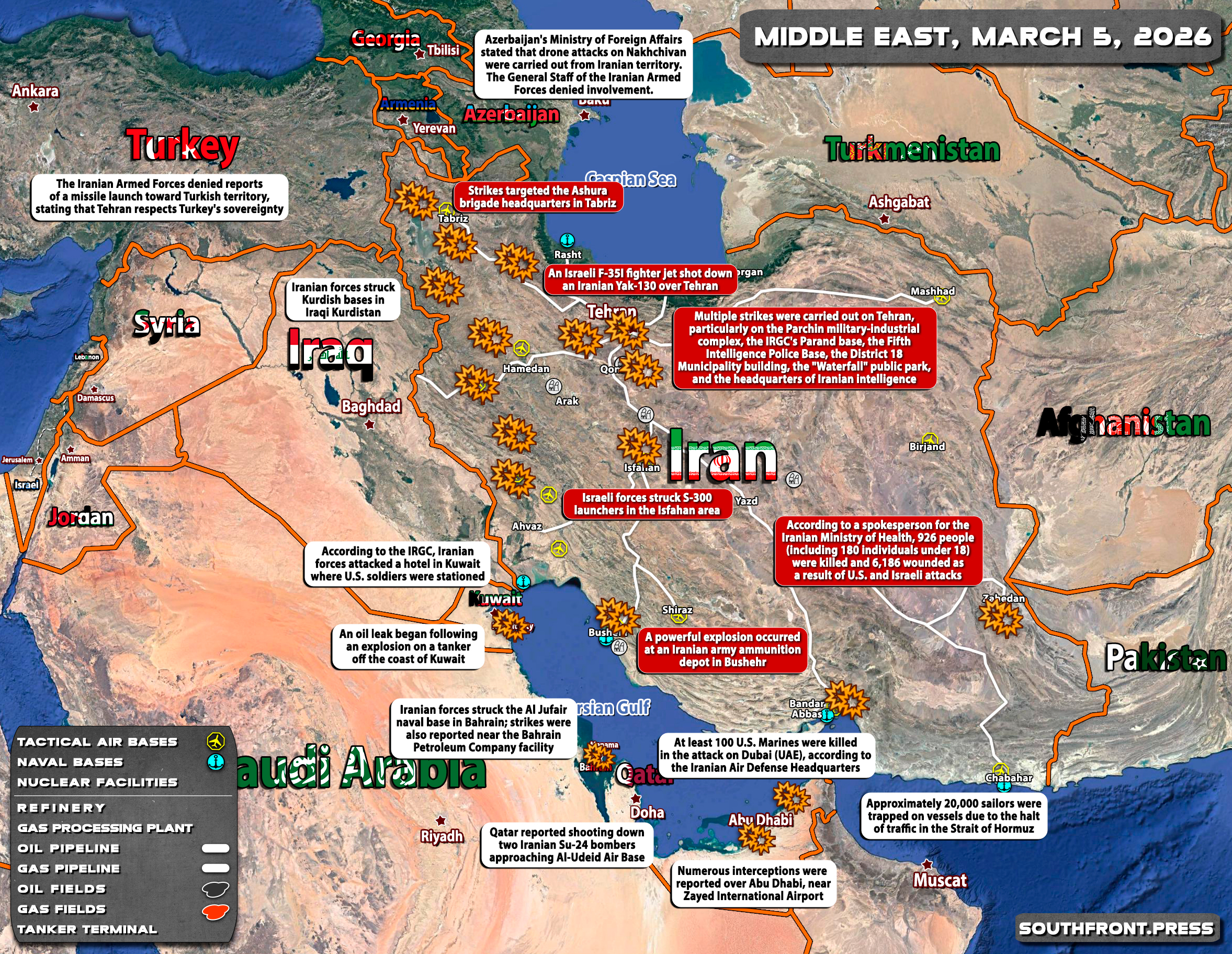
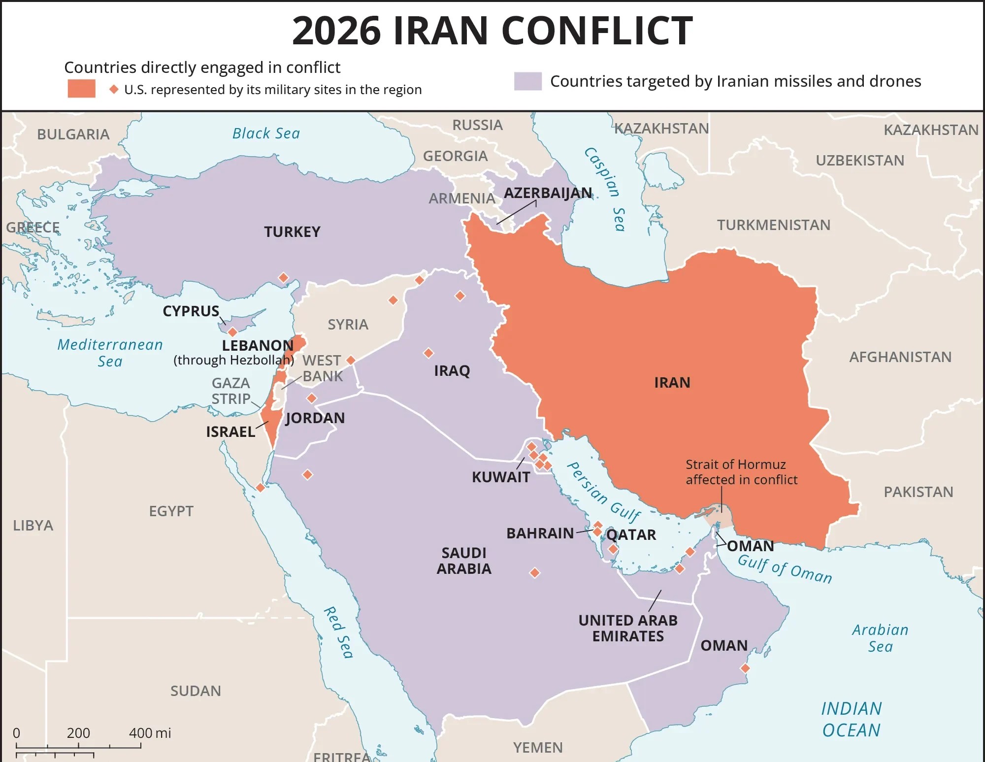
Middle East Geopolitical Risk 2026 Specialeurasia 2026 Oman Safe Airspace Mideast Routings Feb 2026 Syria 3803 Dzie Sprz Tania Wiata KOD UCH 05MAR Map 05MAR Overview April 2026 ACLED Screenshot 2026 At 2026 Is Turkey Diplomacy Warning Of Crisis 2026 Iran Conflict E1772911893903 2026 E1772911893903 Six Key Issues To Watch In 2026 L Orient Today WHATSAPPIMAGE2026 02AT41052PM 615650 WHATSAPPIMAGE2026 02AT41052PM 615650 Document Situation Population Movement June 2026 Big CD9BCFC1D7D9B54C74E9A3FFB1EDEFD000DFACFB Country With Border And Vector Illustration Premium 151293 268 151293 268 Middleeast Political Stock 48323695 Shutterstock 48323695 Borders Flags Image 62737536 File 62737536 UPSC Prelims 2026 Facts Analysis 785a9a10 76AC 4426 B82F 983cc150b558 785a9a10 76AC 4426 B82F 983cc150b558 Detailed Cartoondealer Com 21126497.


2026 Political Map Stock Photos Free Royalty From Wroclaw Poland March World Showing Middle East Region Iran Iraq Saudi Arabia 444507197 Geopolitics 2026 Israel Conflict Global Oil Impact 2026 Tension 2026 In 2026 House Of Commons Library 2025 And Risk Outlook For 2026 Orsam 2025 2026 Scaled 2025 2026 Printable Maps With Airfields Compressed Freight Disruption 11TH 2026 Update Shipping Air Cargo Routes Hi Res Photography Images Alamy 2XM89DG Fuerzas Armadas De Los Estados Unidos America P Gina 246 Am Rica Us Mil Scenarios The To 2026 Worse Before It S Better Soldiers On File Png Large Detailed Relief All Capitals Major Cities.


2026 United States Military Buildup In The Middle East Wikipedia 330PX US Bases 330PX Printable Blank Map Mapdetailed Of 2026 Background Briefings Foreign Policy Centre 2026 Fpcxsepad 2026 Alternate Maps 2024 No Lore R Imaginarymaps 2024 V0 TXD22ZKT1DVC1 2024 V0 TXD22ZKT1DVC1 Airline Stocks Slide As Passengers Scramble To Leave Reuters Graphic Snail Games Unveils ARK Survival Ascended Updates New Titles At GDC Fnc Mapx Iran Could Target CASMII Primer June 2025 Mideast 2025 Freeworldmaps Net Middleeast What Are Main Chart World 2026 Defacto Borders Stock Photos Free Royalty Wooden Blocks Showing Year Placed Detailed Surrounding Regions Concept 417881181.