Where can I get a free map of Rhodes Old Town?
You can typically obtain a free physical map of Rhodes Old Town at major hotels, tourist information centers located in both the Old and New Towns, or often from car rental agencies. These complimentary maps usually highlight key attractions and general street layouts, serving as an excellent starting point for your exploration and understanding the immediate vicinity.
What is the best map app for Rhodes?
For navigating Rhodes, Google Maps and Apple Maps are highly recommended. They offer reliable GPS tracking, turn-by-turn directions, public transport information, and user reviews for local businesses and attractions. Downloading offline maps within these apps before your trip is advisable to ensure continuous navigation even without internet access.
How long does it take to walk across Rhodes Old Town?
Walking across the main thoroughfares of Rhodes Old Town from one gate to another can take approximately 20 to 30 minutes, depending on your pace and detours. However, to truly explore the countless alleys, shops, and historical sites, dedicate at least half a day, or ideally a full day, to fully immerse yourself in its medieval charm.
Are physical maps still useful in Rhodes for tourists?
Yes, physical maps remain incredibly useful in Rhodes for tourists. They offer a broader overview of the town's layout without battery drain, are easy to annotate, and serve as a reliable backup when digital connectivity is limited, especially within the ancient walls. Many travelers appreciate the tactile experience and visual clarity of a paper map.
What attractions are highlighted on a typical Rhodes Town map?
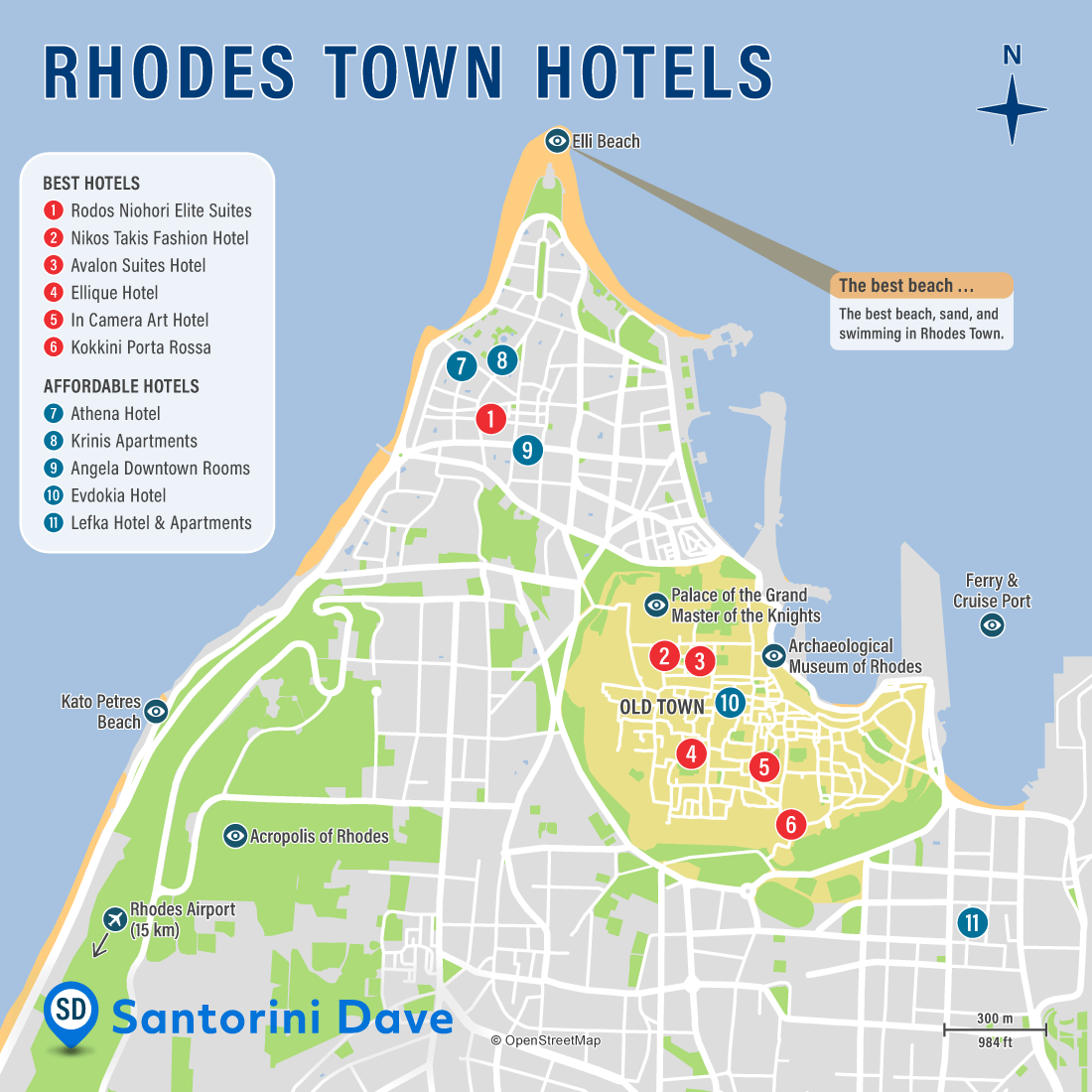
A typical Rhodes Town map highlights major attractions like the Palace of the Grand Master, the Street of the Knights, Mandraki Harbor, the Archaeological Museum, and various medieval gates and fortifications. It also usually indicates churches, mosques, prominent squares, and often includes icons for essential services such as ATMs and public restrooms.
Unlock the secrets of Rhodes Town with an indispensable map guide designed for United States travelers in 2026. This comprehensive resource helps you navigate the ancient cobblestone streets of the Medieval City and the bustling avenues of the New Town with confidence. Discover exactly what a Map of Rhodes Town offers, why it's crucial for maximizing your visit, and how it empowers you to make informed decisions about sightseeing, dining, and local services. Learn to pinpoint key attractions, locate top-rated restaurants, find convenient transportation options, and even identify hidden gems near your current location. This guide provides practical tips on utilizing both digital and physical maps, ensuring you understand availability, compare choices, and confidently explore every corner of this historic Greek island. Plan your Rhodes adventure efficiently, locate essential services, and embark on an unforgettable journey.
Exploring the historic and vibrant destination of Rhodes Town becomes an effortless and enriching experience when you master the art of using its maps. For travelers from the United States, understanding the layout of both the ancient Medieval City and the modern New Town is paramount to a successful vacation. A comprehensive map serves as your most trusted companion, guiding you through labyrinthine alleys, past awe-inspiring historical sites, and towards authentic local eateries. This guide offers practical advice on how to interpret various types of maps and leverage them for seamless navigation, ensuring you discover everything this magnificent island has to offer without missing a single beat.
A well-utilized map of Rhodes Town provides more than just directions; it offers a deeper understanding of the island's rich tapestry of history and culture. By tracing routes through the UNESCO World Heritage-listed Old Town, visitors can immerse themselves in centuries of Knights Hospitaller legacy, identifying landmarks like the Palace of the Grand Master and the Street of the Knights. Beyond its historical significance, the map acts as a vital tool for logistical planning, helping you locate transportation hubs, ATM facilities, and even emergency services. Mastering your map means less time feeling lost and more time creating unforgettable memories, allowing for spontaneous discoveries and a truly personalized adventure through Rhodes.
Understanding the Map of Rhodes Town
What is the Map of Rhodes Town and why is it essential for travelers?
The Map of Rhodes Town is an indispensable navigational tool that visually represents the geographical layout of the island's capital, Rhodes. It meticulously details streets, landmarks, points of interest, public amenities, and often includes public transportation routes. For United States travelers in 2026, this map is not merely a piece of paper or a digital image; it is a gateway to efficiently experiencing the island's dual charm – the ancient, walled city and the modern, bustling commercial areas. Without a reliable map, visitors risk wasting precious vacation time wandering aimlessly or missing key attractions and authentic local experiences that lie just beyond the main tourist paths.
Its essential nature stems from the unique structure of Rhodes Town, particularly the Medieval Old Town, which boasts a complex network of narrow, winding streets designed for defense, not straightforward navigation. A detailed map helps visitors understand this intricate design, allowing them to confidently explore hidden courtyards, artisan shops, and tucked-away cafes. Furthermore, the map provides crucial context by illustrating the proximity of different neighborhoods and attractions, aiding in itinerary planning. It highlights the distinction between the historical core and the contemporary areas, ensuring travelers can seamlessly transition from ancient wonders to modern conveniences like shopping districts and vibrant nightlife.
Beyond basic directions, an optimized Map of Rhodes Town empowers travelers to make informed decisions and personalize their trip. It serves as a visual guide for comparing distances between hotels and desired attractions, identifying dining options with specific cuisines, or locating highly-rated service providers. By referencing the map, you can effectively plan walking tours, discover bicycle rental locations, or even coordinate pick-up points for excursions, all contributing to a stress-free and enjoyable visit. It transforms potential navigational challenges into exciting opportunities for exploration, making every step an intentional discovery.
Navigating Rhodes Town Like a Local
How can I effectively use a map to explore Rhodes Old Town?
To effectively explore Rhodes Old Town using a map, begin by identifying the main gates, such as the Liberty Gate or Marine Gate, as entry and exit points. Orient yourself by locating major landmarks like the Palace of the Grand Master, which acts as a central beacon within the Medieval City. The Old Town's charm lies in its winding, pedestrian-only streets, so focus on major arteries initially, then branch out to explore smaller alleys. Digital maps offer GPS tracking to constantly show your position, which is invaluable in a labyrinthine environment, while physical maps allow for a broader overview and easier annotation of discovered gems. Always note nearby cafes or shops as mental markers for easier backtracking.
For a truly immersive experience, plan your route around specific themes or interests. If you seek historical depth, use the map to trace the Street of the Knights, stopping at various inns representing different European orders. For shopping, identify commercial streets where local artisans and souvenir shops are concentrated. Many maps will highlight these areas or provide icons for points of interest. Consider mapping out a morning itinerary for cultural sites and an afternoon one for leisure or food exploration. Having a rough plan helps avoid decision fatigue and ensures you cover your must-see spots efficiently, allowing for spontaneous detours without feeling completely lost.
When utilizing a physical map, remember to unfold it fully in a safe, uncrowded spot to get a complete perspective. Mark your hotel and any pre-booked reservations. If using a digital map on your phone, download offline versions to conserve data and battery, especially in areas with limited signal, like inside ancient walls. Utilize zoom functions to delve into street names and specific building layouts. Both map types benefit from understanding cardinal directions; while the Old Town's streets rarely run perfectly north-south, knowing your general orientation helps immensely. Remember that the joy of Rhodes is also in getting a little lost and finding something unexpected, so allow for some unplanned exploration within your mapped boundaries.
What are the best types of maps for finding attractions and services in Rhodes?
For finding attractions and services in Rhodes, a combination of digital and physical maps offers the most robust solution. Digital map applications, such as Google Maps or Apple Maps, are exceptional for real-time navigation, offering turn-by-turn directions, estimated travel times, and up-to-date information on business hours and reviews for restaurants, shops, and attractions. These apps are particularly useful for locating specific addresses, finding public transportation routes, or identifying services like ATMs or pharmacies with a quick 'near me' search. Their dynamic nature means they are constantly updated, providing the most current data on road closures or new establishments, which is a significant advantage for US travelers in 2026 seeking immediate, actionable information.
Conversely, a high-quality physical tourist map provides an invaluable static overview, free from battery drain or connectivity issues. These maps often feature artistic representations of landmarks, highlight key historical areas, and sometimes include a directory of services tailored for visitors. A good physical map excels at helping you visualize the overall layout of Rhodes Town, making it easier to plan extensive walking tours or understand the relationship between different districts. You can typically acquire these free at hotels, tourist information centers, or purchase more detailed versions at local bookstores. Many travelers find comfort in being able to spread out a large paper map to absorb the geography without distraction.
For optimal results, consider using a dedicated tourist map alongside a general digital map. The tourist map can point out specific points of interest and offer curated routes, while the digital map handles the granular navigation between those points and helps locate essential services on the fly. Some specialized apps or downloadable PDF maps might also be available, focusing solely on the Medieval City with enhanced details on archaeological sites or specific walking paths. Prioritize maps that clearly differentiate between pedestrian-only zones and vehicle-accessible roads, and look for those that include topographic details if you plan on exploring beyond the main town areas, ensuring you're prepared for any terrain.
Key Areas and Points of Interest
Which areas should I focus on when using a Rhodes Town map for sightseeing?
When using a Rhodes Town map for sightseeing, your primary focus should be the Medieval City, a UNESCO World Heritage site often referred to as the Old Town. This area is enclosed by formidable walls and is a treasure trove of historical and cultural landmarks. Key points to identify on your map include the Palace of the Grand Master of the Knights of Rhodes, the Street of the Knights, and the Archaeological Museum, housed in the former Hospital of the Knights. Spend time tracing the labyrinthine alleys, discovering charming squares like Ippokratous Square, and visiting ancient mosques and synagogues. A detailed map will help you navigate these winding paths without getting overwhelmed, allowing you to prioritize the sites that most captivate your interest.
Beyond the Old Town, the New Town of Rhodes offers a different, yet equally engaging, sightseeing experience. On your map, locate Mandraki Harbor, recognizable by its iconic deer statues and the windmills, which is a central point for boat tours and ferries to nearby islands. The New Town also features impressive Italianate architecture from the Fascist era, notably around the area of the Government House and the Church of Annunciation. For shopping and dining, identify areas like the streets surrounding Cypro Street or those near the town's main squares. Maps are crucial here for understanding the layout of commercial districts and finding specific stores, restaurants, or cafes that align with your transactional intent, like booking a tour or finding local artisan crafts.
To truly maximize your sightseeing, ensure your map highlights the natural borders and connections between these distinct areas. Look for the points where the Old Town walls meet the New Town, offering strategic entry and exit points. Consider identifying locations for public parks or waterfront promenades for relaxation after extensive historical exploration. Many maps will also indicate bus stops or taxi stands, which are essential for navigating between the Old and New Towns, especially if you plan to visit attractions further afield. By focusing on these interconnected zones, your map transforms into a comprehensive guide, ensuring you experience the full spectrum of Rhodes Town's allure, from its ancient past to its vibrant present, making every decision and action well-informed and effortless.
Making the Most of Your Rhodes Experience
What common mistakes should I avoid when using a map in Rhodes Town?
One common mistake when using a map in Rhodes Town is relying solely on digital maps without an offline alternative or a power bank. While incredibly useful for real-time navigation, phone batteries can deplete quickly, especially with constant GPS use. Losing your map access in the middle of the winding Old Town can be frustrating and disruptive to your sightseeing plans. Always download offline maps for the entire island before you arrive and carry a portable charger or a physical backup map. This proactive approach ensures uninterrupted exploration, allowing you to confidently locate points of interest, find directions back to your accommodation, or search for nearby services even without a data connection.
Another frequent error is underestimating the intricate layout of the Medieval City. Many first-time visitors expect a simple grid system, but the Old Town is a maze of narrow, often unnamed streets and alleys. Trying to navigate purely by instinct can lead to getting pleasantly lost, but also potentially missing crucial landmarks or important appointments. Take a moment to orient yourself regularly, comparing your surroundings with the map. Look for prominent landmarks, unique building facades, or street signs as reference points. Don't be afraid to ask for directions; locals are generally friendly and helpful, but having a clear idea of your destination on the map will make communication much easier and more precise.
Finally, a significant mistake is neglecting to review the map for potential hazards or areas of limited access, particularly if you are considering a leisurely stroll. Some parts of the Old Town may have uneven cobblestones, steep inclines, or areas that are less accessible for individuals with mobility challenges. Consulting your map beforehand can help you identify more comfortable routes or suitable entry points. Additionally, be aware of peak tourist times when certain narrow passages become extremely crowded; the map can help you find alternative, quieter routes to reach your destination. Thoughtful map usage minimizes frustration and maximizes your enjoyment of Rhodes Town's unique historical ambiance.
Frequently Asked Questions about Rhodes Town Maps
For visitors from the United States, understanding the best ways to navigate Rhodes Town can greatly enhance their travel experience. Many queries revolve around obtaining maps, utilizing technology for directions, and identifying key features for efficient exploration. These frequently asked questions aim to provide clear, actionable answers that address common concerns and optimize your journey through this historic Greek destination. By addressing these points, travelers can confidently plan their routes, locate attractions, and make the most of their time on the island, ensuring a smooth and enjoyable visit whether they're searching for ancient ruins or the nearest cafe. This section compiles essential information to help you get around effortlessly.
A primary concern for many travelers is how to acquire reliable maps and whether digital or physical versions are more effective for navigating Rhodes Town's diverse landscape. This section delves into the practicalities of obtaining maps, from free resources available upon arrival to the benefits of dedicated navigation apps. We explore scenarios where a traditional paper map might outweigh the convenience of a smartphone, especially in areas with spotty internet service or for those who prefer a tactile guide. Understanding these nuances allows for a flexible approach to navigation, catering to individual preferences and ensuring you always have a dependable tool at hand, regardless of your location within the town or your immediate needs.
Beyond mere acquisition, knowing how to interpret map features and leverage them for specific purposes is key. This part of our FAQ focuses on practical application: how to identify major attractions, locate public transport hubs, find recommended dining spots, or even discover hidden gems away from the crowds. We also touch upon common navigational challenges specific to Rhodes Town, such as distinguishing between the Medieval Old Town's intricate pathways and the more structured New Town. By providing clear guidance on these aspects, we aim to empower US travelers to move confidently and efficiently, transforming potential logistical hurdles into opportunities for exciting discoveries and a truly memorable Rhodes adventure.
Key highlights
Rhodes Old Town map, New Town navigation, best Rhodes tourist map, Rhodes attractions map, where to get a Rhodes map, Rhodes walking tour map, interactive Rhodes guide, local Rhodes points of interest, finding services in Rhodes
In pictures


Rhodes City Tourist Map Ontheworldmap Com TAXI TOURS Private Excursions Old Town A Collection During The Google Days Tourism Info Web Sites Of Photos Cappadociaconcepttour EB036C3E2969BF2954869195331121B0 Good Street Message Board Tripadvisor RHODES2BCITY2BMAP Attractions Arptravels BBAA8E0E57303655C239010C082663B4 Island Rhodesinfo Gr Travel Guide Medieval Sightseeing Beaches Greece D80B28901C37B21ABA4F36187B7C9756 Rodi 7830390eceee314a74269a61cc3916e7.


Rhodes Tourist Attractions Map Photos Arptravels Com 2af467bd0ef97e757110420aae55ed10 Guidebookbali On Your Own TOWN HOTEL Best Places To Stay Bus Timetable 2026 Rhodesoldtown Gr Old And Street Directory Cappadociaconcepttour City Informations Touristiques 019 Ville Carte 019 Of With Cities Towns Greece EBC826EE5C726416CC61BA5C14A1F08C Free Self Guided Walking Tour Mod Zoomed Port Ferry Locations The Mediterranean Traveller Island Greeka 5F6ECDC1A9BC26FDEED351E78F4D06FD.


Rhodes Map Of Island Greece Large Town Tourist Willowstreehousetreasures Com Where To Stay In Road 1200 Free Self Guided Old Walking Tour With Liberty Gate Airbnb Data 2026 Revenue Occupancy ROI Insights Airbtics Google Maps 138229 Gr 138229 Walk Photos Guidebookbali Simple The Greek Vector 50718497 Interactive City Ville Carte 001 Street 68d85289b4a37c90be4751d419081071 Cappadociaconcepttour 39975455102 EC68093D04 B 39975455102 EC68093D04 Tourism Info Web Sites.