Where is Sicily relative to mainland Italy?
Sicily is located directly southwest of mainland Italy, separated by the narrow Strait of Messina. It is the largest island in the Mediterranean Sea, positioned at the 'toe' of Italy's distinctive 'boot' shape. This close proximity makes it easily accessible by ferry from various points on the mainland, serving as a natural extension of the Italian peninsula.
What major bodies of water surround Sicily?
Sicily is surrounded by the Mediterranean Sea, which is further divided into specific areas around the island. To its north lies the Tyrrhenian Sea, to its east, the Ionian Sea, and to its southwest, the Strait of Sicily which separates it from North Africa. These waters have profoundly influenced its climate, history, and maritime culture.
Is Sicily easily accessible from the United States?
Yes, Sicily is accessible from the United States, typically requiring a connecting flight. While there are no direct flights from the US to Sicily's airports (Palermo or Catania), travelers can fly into major European hubs or mainland Italian cities like Rome or Milan, then take a connecting flight or train/ferry to Sicily. Planning connections carefully ensures a smooth journey.
What geographical features are prominent on a map of Sicily?
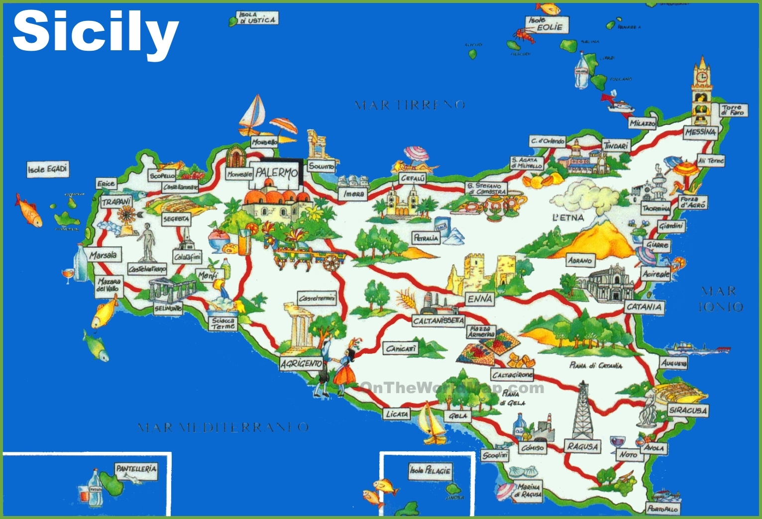
Prominent geographical features on a map of Sicily include Mount Etna, Europe's most active volcano, located on the eastern side. The island also features several mountain ranges, such as the Madonie, Nebrodi, and Peloritani mountains. Its extensive coastline, dotted with numerous bays, beaches, and historic port cities, is another key characteristic. These diverse features contribute to Sicily's varied landscapes.
How does Sicily's location impact its cultural identity?
Sicily's central Mediterranean location has made it a historical crossroads, leading to a rich blend of cultures from successive invaders and settlers. Its map shows proximity to North Africa, the Middle East, and mainland Europe, reflected in its unique Arab-Norman architecture, Greek temples, Roman amphitheaters, and distinct culinary traditions. This geographical position fostered a unique syncretism, creating an identity distinct from mainland Italy.
Discover Sicily's precise location on a world map and understand its geographical significance for United States travelers. This comprehensive guide provides essential navigational context, detailing Sicily's position within the Mediterranean Sea and its relationship to Italy and North Africa. Learn how its strategic placement has shaped its rich history, culture, and diverse landscapes. We explore practical ways to utilize maps for planning your visit, identifying key regions, and navigating the island's unique terrain. Understand why knowing Sicily's exact global coordinates is crucial for informed travel decisions, from choosing flights to exploring local attractions. This resource helps you visualize your journey and prepare for an unforgettable experience on this captivating Italian island.
Questions & answers
How far is Sicily from the Italian mainland?
Sicily is separated from the Italian mainland by the Strait of Messina, which is only about 3 kilometers (less than 2 miles) wide at its narrowest point. This short distance allows for frequent ferry services connecting Messina on Sicily with Villa San Giovanni and Reggio Calabria on the mainland, making travel between the two relatively quick and easy.
What are Sicily's main airports for international travelers?
Sicily's two primary international airports for travelers are Falcone Borsellino Airport (PMO) near Palermo, serving the western side of the island, and Catania Fontanarossa Airport (CTA), located on the eastern side. Both airports offer numerous connections to major European cities, facilitating convenient access for United States visitors.
Is Sicily considered part of Europe or Africa geographically?
Geographically, Sicily is definitively part of Europe. It is an autonomous region of Italy, situated in the Mediterranean Sea south of the European continent. While its proximity to North Africa has led to significant cultural influences, its landmass and political affiliation place it firmly within the European geographical and political sphere.
Can I drive from mainland Italy to Sicily with my car?
Yes, you can drive your car from mainland Italy to Sicily. There are regular car ferry services operating across the Strait of Messina, primarily between Villa San Giovanni (Calabria) and Messina (Sicily). These ferries allow vehicles to cross, providing a direct and convenient way for travelers to bring their cars onto the island.
What is the best time of year for US travelers to visit Sicily based on its location?
The best time for US travelers to visit Sicily, leveraging its Mediterranean location, is typically during the spring (April-May) or fall (September-October). During these months, the weather is pleasantly mild, perfect for sightseeing and outdoor activities, and avoids the intense heat and larger crowds of the peak summer season, offering a more comfortable experience.
Are there any smaller islands near Sicily I can visit?
Yes, Sicily is surrounded by several captivating smaller archipelagos, perfect for day trips or extended stays. These include the Aeolian Islands to the north, known for their volcanic landscapes; the Egadi Islands to the west, famous for crystal-clear waters; and the Pelagie Islands to the south, closer to Africa. Each offers unique natural beauty and charm.
Introduction to Sicily's Location
Understanding Sicily's exact position on a world map is the first crucial step for any prospective traveler, especially those from the United States planning an international adventure. Sicily, a jewel of the Mediterranean, holds a significant place geographically and historically. Its location influences everything from its climate and cuisine to its unique cultural tapestry, blending European, African, and Middle Eastern elements. Visualizing this island on a global scale helps travelers grasp the distances involved, anticipate travel times, and appreciate the strategic importance of this Italian region.
For US citizens, pinpointing Sicily on a world map provides critical context for trip planning. It clarifies its proximity to mainland Italy, the boot-shaped peninsula, and its commanding presence in the central Mediterranean. This foundational geographical knowledge empowers you to make informed decisions about flight paths, ferry routes, and potential multi-country itineraries. By first establishing its global coordinates, you unlock a deeper understanding of the island's accessibility and its role as a crossroads of civilizations for millennia, a truly unique destination.
Furthermore, comprehending Sicily's geographical setting helps in appreciating its diverse natural beauty, from volcanic landscapes to pristine coastlines. Knowing its location means understanding its position relative to major shipping lanes and ancient trade routes, which have continuously shaped its identity. For those seeking an immersive travel experience, recognizing Sicily's place on the world stage enriches every aspect of your journey, transforming a simple visit into an educational and culturally profound exploration of one of Europe's most captivating islands.
Where Exactly is Sicily on a World Map?
Sicily is unequivocally located in Southern Europe, specifically as the largest island in the Mediterranean Sea. It forms an autonomous region of Italy, separated from the Italian mainland by the narrow Strait of Messina. If you trace the 'boot' of Italy on a map, Sicily appears to be kicked by its toe, lying just southwest. Its coordinates place it roughly between latitudes 36 and 38 degrees North and longitudes 12 and 15 degrees East, positioning it squarely in the Northern Hemisphere and Eastern Hemisphere. This central Mediterranean placement gives it a unique blend of climates and influences.
Zooming out to a world map, Sicily is prominently situated south of mainland Europe, east of Tunisia in North Africa, and west of Greece. This strategic location has made it a coveted territory throughout history, attracting numerous civilizations including the Phoenicians, Greeks, Romans, Arabs, and Normans, each leaving an indelible mark. For US travelers, understanding this global context helps frame Sicily not just as a part of Italy, but as a historically significant crossroads influencing regional dynamics and global trade routes for centuries.
Its position means it is easily accessible from major European hubs, often requiring connecting flights for those arriving from the United States. Direct flights from the US typically land on the Italian mainland, with subsequent connections to Sicily's international airports in Palermo or Catania. This island's location is a key factor in its appeal, offering a Mediterranean escape that feels both historically rich and geographically distinct from other European destinations, a true gem for exploration.
Why Understand Sicily's Geographical Context?
Understanding Sicily's geographical context extends beyond mere location; it's fundamental to appreciating its unique character and planning an optimal travel experience from the US. The island's position as a bridge between Europe and Africa has cultivated a fascinating blend of cultures, architectures, and cuisines. From the Greek temples of Agrigento to the Arab-Norman cathedrals of Palermo, the geographical crossroads are reflected in every corner of the island, offering a diverse historical narrative that travelers can explore.
Moreover, Sicily's geography directly impacts its climate and agricultural bounty. Its Mediterranean climate, characterized by hot, dry summers and mild, wet winters, is a direct result of its latitudinal position and surrounding sea. This allows for the cultivation of citrus fruits, olives, and grapes, which are central to its renowned culinary traditions. For food enthusiasts, knowing the island's geographical zones helps identify the origins of famous produce and regional specialties, enhancing their gastronomic journey.
For logistical planning, recognizing Sicily's size and internal geography is vital. It's a large island with varied terrain, including the active volcano Mount Etna, rugged mountains, and extensive coastlines. This diversity means travel within Sicily requires careful planning regarding transportation and time allocation. Understanding the distances between cities and attractions, and the types of roads connecting them, helps US visitors set realistic itineraries, ensuring a smooth and enjoyable exploration of this multifaceted destination.
Navigating Sicily and Its Regions
How to Interpret a Sicily World Map for Travel?
Interpreting a Sicily world map for travel involves understanding its scale and features relevant to your journey. While a world map shows Sicily's global position, you will need more detailed regional and local maps once on the ground or during meticulous planning. Pay attention to major cities like Palermo, Catania, Syracuse, and Messina, which serve as key entry points and hubs for exploration. Locate the main highways and arterial roads connecting these cities, as they will be crucial for self-driving tours. Identifying geographical features like Mount Etna, the Ionian Sea coast, and the Tyrrhenian Sea coast helps orient you and understand the varied landscapes you'll encounter.
When examining a map, look for topographical details that indicate mountain ranges and coastal plains. Sicily's interior is largely mountainous, which can impact travel times and road conditions. Coastal areas tend to be flatter and more developed. Maps will also highlight natural parks and protected areas, which are excellent for outdoor activities and require specific access routes. Understanding these elements from a map allows you to visualize potential driving routes, estimate journey durations, and determine if public transport options are viable for your chosen destinations. Always cross-reference map data with current road conditions and travel advisories, especially if planning to drive off the main routes, for the most practical and safe itinerary.
For US travelers, using modern digital mapping tools like Google Maps or Apple Maps is highly recommended, as they offer real-time traffic updates, public transport options, and walking directions within cities. However, a good physical map can be an invaluable backup, especially in rural areas where mobile signal might be intermittent. Focus on maps that clearly label towns, villages, and points of interest. Consider maps specifically designed for tourists, which often include attractions, hotels, and ferry terminals. Effective map interpretation means synthesizing geographical information with practical travel logistics to create a seamless and enjoyable Sicilian adventure, focusing on the routes and regions most appealing to you.
Which Regions of Sicily Should I Explore Using a Map?
Exploring Sicily effectively with a map means identifying regions that align with your travel interests. The island can be broadly divided into several distinct areas, each offering unique attractions. Western Sicily, centered around the capital Palermo, boasts a rich history with Arab-Norman architecture, vibrant markets, and proximity to picturesque coastal towns like Cefalù and the ancient Greek site of Segesta. Mapping out this region allows for a deep dive into historical cities, enabling travelers to navigate winding streets and discover hidden gems efficiently. Focus on routes connecting Palermo with Trapani, Agrigento, and Marsala for a comprehensive western experience.
Eastern Sicily, dominated by the active volcano Mount Etna and the cities of Catania and Syracuse, offers a different allure. Catania provides a gritty, authentic Sicilian experience, while Syracuse is renowned for its Greek and Roman ruins, particularly the Archaeological Park of Neapolis and the charming island of Ortigia. Mapping routes around Etna is crucial for volcano tours, while coastal maps guide you to beautiful beaches and the dramatic Taormina. This region is ideal for those interested in ancient history, volcanic landscapes, and stunning coastal vistas. Consider routes that link Catania, Taormina, Syracuse, and Noto for an eastern exploration.
Southern Sicily, featuring the Valley of the Temples in Agrigento and the baroque towns of the Val di Noto (like Ragusa, Modica, and Noto), is a UNESCO World Heritage treasure. This area provides a serene, culturally rich experience focused on ancient Greek civilization and opulent baroque artistry. Using a map here helps connect these charming towns, often situated on hilltops, revealing scenic drives through agricultural landscapes. Planning to combine Agrigento with the baroque towns requires mapping efficient routes, often through less direct but highly rewarding country roads. Each region promises distinct experiences, and a detailed map is your essential tool for unlocking their full potential.
Practical Tips for Using a Sicily World Map
What Are Common Mistakes When Planning with a Sicily Map?
A common mistake when planning a trip to Sicily using a map is underestimating the island's size and the time required to travel between destinations. While Sicily might appear compact on a world map, its mountainous interior, winding roads, and often slower rural transit mean that a 100-kilometer journey can easily take two hours or more, especially if you venture off main highways. Many US travelers tend to over-schedule their itineraries, attempting to cram too many locations into a single day. Always factor in extra time for scenic stops, unexpected road closures, or simply enjoying the local atmosphere, ensuring a more relaxed and immersive travel experience.
Another frequent error is relying solely on basic digital maps without considering the terrain and road conditions. While Google Maps provides excellent routing, it may not always reflect the narrowness of some Sicilian roads, particularly in smaller villages or mountainous areas, which can be challenging for larger vehicles or inexperienced drivers. Physical maps often offer a better overview of elevation changes and road classifications, helping you anticipate more demanding drives. Always consult a combination of digital and physical maps, and read recent traveler reviews about road quality for your specific routes to avoid surprises and ensure a comfortable journey.
Finally, overlooking the importance of local transportation nuances is a significant planning mistake. Many maps highlight major train lines, but bus services are often more extensive, connecting smaller towns not served by rail. Public transport schedules can be less frequent on weekends or during off-season, which isn't always evident on a standard map. Additionally, parking in Sicilian cities can be notoriously difficult and expensive, so planning accommodation with parking or researching public parking garages beforehand is crucial. By being aware of these common pitfalls, US visitors can leverage their maps more effectively to create a realistic and enjoyable Sicilian itinerary, avoiding unnecessary stress.
Where Can I Find Reliable Sicily Maps for My Trip?
Finding reliable Sicily maps for your trip is essential for successful navigation, and thankfully, several excellent resources are available to US travelers. For digital maps, Google Maps and Apple Maps are indispensable, offering real-time traffic updates, extensive points of interest, public transportation routes, and detailed street views. These apps allow you to download offline maps before your trip, which is incredibly useful for areas with limited cellular service. They also integrate seamlessly with accommodation and attraction searches, providing a comprehensive digital planning tool that most travelers find indispensable for navigating both urban and rural Sicily with ease.
For physical maps, purchasing a high-quality road map before you depart can be a wise investment. Brands like Michelin or Touring Club Italiano (TCI) are renowned for their accurate and detailed maps, often available at bookstores, online retailers like Amazon, or specialty travel stores in the United States. These maps typically include topographical information, scenic routes, and points of interest, making them excellent for planning longer drives or exploring rural areas where a digital signal might be unreliable. A good physical map serves as an excellent backup and allows for a broader, uninterrupted overview of the island's geography, enhancing your trip planning.
Upon arrival in Sicily, you can often find local maps at tourist information offices, major train stations, and airports in cities like Palermo and Catania. These local maps are usually free and can be highly detailed for specific cities or regions, highlighting attractions, public transport stops, and pedestrian zones. Additionally, many hotels and B&Bs provide guests with local area maps or recommendations. Combining these diverse map resources—digital for real-time navigation, a detailed physical map for overall planning, and local maps for specific city exploration—ensures you are well-equipped to confidently navigate every corner of Sicily, from its bustling cities to its tranquil countryside.
Key highlights
Sicily location on world map, where is Sicily, map of Sicily Italy, Mediterranean Sea position, navigating Sicily routes, Sicily travel planning, understanding Sicily geography, island of Sicily on maps, US traveler guide Sicily, best way to find Sicily
In pictures


Map Showing The Position Of Sicily In South Italy Edited From Google Earth Ppm Provinces Ontheworldmap Com Royalty Free Stock Image 28161966 Is Part Everything You Need To Know Tours 2026 Portugalessence Depth Physical And Africa Strait Gray Political Also Called Sicilian Channel Located Mediterranean Sea Between Tunisia 2RWTFJH 2026 206869 202502271532 206869 202502271532 History Geography People Britannica 2026 Insidesicily Ou 2024RESIZE Large Detailed With Cities Towns Intended For Printable Templates Scaled.


Italy Maps Facts World Atlas Intended For Map Of With Sicily To Travel Is Live 1748297 Printable Online In The Karte US Tours Trips 2025 2027 Global Journeys 158080 2026 Portugalessence Com Explore Catania Palermo Mount Etna 2026 Web 2026 2026 Best Tour Day Affordable Quick Guide Helene Between Road Trip Plan Ultimate Itinerary Two Destination 2026 Awesome Guides Article 2fff77b4 AC82 410F 9c7 Infographic Style Chart Illustrating Sicilys 2026 5ENCZH 2fff77b4 AC82 410F 9c7 2026 5ENCZH Historic Wall 1941 Mapworld Nla Obj 283529289.


Pokemon Gen Discussion Thread Of Hopes Speculation Expectations Sicily Region Sicilia Map 1478 930 1478 930 Destination Guide Explore The Best 2026 Awesome Travel Guides Featured 2026 Sckxbs 2026 Malta Vs Which Should You Visit In 2026 Old World Collette Tour 710 M Lo 710 Tours 2026 Portugalessence Com Travelstride Adventure Tailor Made Trip Reviews 14ACD888B916A809D0EA27E8DA347F9A Italy Facts And Information About Places L Where Is Located A Country Europe Free Printable Relief Antique F Naymiller Idea Rare Maps Pagnoni Min Scaled.