What is the best way to get a physical map of Uttaranchal?
To acquire a reliable physical map of Uttaranchal, U.S. travelers can purchase them from major bookstores in India, especially in cities like Delhi or Dehradun, or from specialized trekking shops. The Survey of India also offers highly detailed topographical maps. Online retailers may also provide options for international shipping. Always check the publication date to ensure the map is current and reflects recent infrastructure changes, providing the most accurate navigational aid for your journey.
Are Google Maps reliable for navigating Uttaranchal?
Google Maps can be reliable for navigating Uttaranchal's major towns and highways, offering real-time traffic and directions. However, its accuracy may diminish in remote mountain areas, where network coverage is sparse or roads are unpaved. Always download offline maps for areas with limited connectivity and consider a physical map as a backup for trekking or exploring off-grid locations, ensuring continuous and trustworthy navigation throughout your trip.
Can I use maps to find local attractions near me in Uttaranchal?
Yes, maps are excellent tools for finding local attractions near you in Uttaranchal. Digital maps often feature points of interest, including temples, waterfalls, markets, and viewpoints, with integrated search functions. Physical tourist maps frequently highlight key attractions and scenic spots, often with descriptive notes. Utilizing both digital and physical maps allows you to discover well-known sites and uncover hidden gems, enriching your travel experience with diverse local attractions.
What should I look for in a trekking map for the Himalayas in Uttaranchal?
For a trekking map in Uttaranchal's Himalayas, prioritize a large scale (e.g., 1:50,000) for detailed topography, including elevation contours, water sources, and established trails. Look for maps with clear symbols, English legends, and an accurate representation of the terrain. Reputable publishers like the Survey of India or specialized trekking guide map providers are generally best. Ensure the map is waterproof and tear-resistant for durability during rugged outdoor use, providing essential guidance on your adventure.
How do I plan transportation using a map in Uttaranchal?
To plan transportation in Uttaranchal using a map, identify your starting and destination points, then examine major roads, highways, and railway lines connecting them. Digital maps provide public transport options and driving directions with estimated times. For local travel, physical maps can indicate bus routes or taxi stands in towns. Always cross-reference map information with local transport schedules and inquire about availability and pricing for options like taxis or shared jeeps to optimize your journey efficiently.
Unlock seamless travel planning for Uttaranchal, also known as Uttarakhand, with an optimized map. This comprehensive guide helps U.S. travelers navigate the majestic Himalayas, discover sacred sites, and explore vibrant local culture. Understanding the terrain and key locations is crucial for a rewarding trip. Learn where to access detailed digital and physical maps, compare their features, and determine which best suits your adventure, whether you are planning a serene spiritual retreat or an exhilarating trekking expedition. Find information on local transportation routes, essential points of interest, and the best ways to get around. This resource will clarify available options, provide insights into map accuracy, and guide you in making informed decisions for your journey, ensuring you have the right navigational tools at your fingertips. Discover how to utilize maps for booking accommodations, identifying local services near me, checking accessibility, and planning efficient travel itineraries to maximize your experience in this beautiful Indian state.
Questions & answers
What is the best type of map for trekking in Uttaranchal's Himalayas?
The best map for Himalayan trekking in Uttaranchal is a detailed topographical map with a large scale (e.g., 1:50,000). These maps provide crucial information on elevation, trails, and water sources, essential for safe navigation. Obtain them from specialized outdoor shops or the Survey of India, ensuring they are waterproof and recent for accuracy during your adventure.
How reliable are digital maps in Uttaranchal's remote areas?
Digital maps offer convenience in Uttaranchal's urban areas and on major highways. However, in remote or mountainous regions, cellular network and GPS signal reliability can be limited. Always download offline maps before venturing into these areas and consider carrying a physical backup map to ensure continuous and dependable navigation when connectivity is unavailable.
Can I find local restaurants and hotels on Uttaranchal maps?
Yes, modern digital maps, such as Google Maps, often integrate local businesses, including restaurants and hotels, complete with reviews, contact details, and directions. Physical tourist maps may also highlight prominent accommodations and eateries in popular destinations. Utilizing these features helps you easily locate services near your current position for convenience.
What are the most common mistakes travelers make with maps in Uttaranchal?
Common mapping mistakes in Uttaranchal include over-relying on digital maps in areas with no signal, underestimating mountain travel times, and neglecting a physical backup. Travelers often fail to check for current road conditions or seek local advice, leading to unexpected delays or reroutes. Always download offline maps and carry a physical map.
Where can I buy a good physical road map for Uttaranchal?
You can purchase reliable physical road maps for Uttaranchal from major bookstores in large Indian cities like Delhi or Dehradun, or from tourist information centers. Specialized travel and trekking shops also stock detailed regional maps. Always verify the map's publication date to ensure it is current and accurate for your travel planning and navigation.
How do I ensure my map is up-to-date for Uttaranchal travel?
To ensure your map is up-to-date for Uttaranchal travel, prioritize maps with recent publication dates, ideally within the last year or two. For digital maps, ensure your app is regularly updated. Cross-reference map information with local news, road reports, or by consulting local guides for any recent infrastructure changes, road closures, or new developments that might not yet appear on printed maps.
Planning a trip to Uttaranchal, often referred to as Uttarakhand, requires reliable navigation tools to fully appreciate its diverse landscapes, from snow-capped peaks to lush valleys and sacred rivers. For travelers from the United States, understanding the geographical nuances through a detailed map is paramount for both safety and enjoyment. This guide focuses on equipping you with the knowledge to select and utilize the most effective maps, whether you are a seasoned explorer or a first-time visitor. We delve into various map types, their benefits, and how they can enhance your journey through this enchanting Indian state, ensuring you are well-prepared for any adventure ahead.
Effective mapping goes beyond just showing roads; it offers a deeper insight into the region's topography, cultural sites, and local services. A good map can help you identify unique vantage points, locate authentic local eateries near you, and even understand historical trails. We recognize that U.S. travelers seek practical, actionable information, and this content aims to deliver just that. By providing clear guidance on where to find, compare, and apply different mapping solutions, we empower you to craft an itinerary that is both efficient and enriching, avoiding common travel pitfalls and maximizing your precious vacation time.
What Makes an Ideal Map for Uttaranchal Travel?
How do I choose the best map for my trip to Uttaranchal?
Selecting the ideal map for Uttaranchal depends on your specific travel style and intended activities. For extensive trekking or exploring remote areas, detailed topographical maps are essential, often available through specialized outdoor retailers or government survey offices in India. These maps offer intricate details on elevation, water bodies, and trails, proving invaluable when navigating challenging terrain. Conversely, if your journey focuses on visiting popular tourist destinations, religious sites like Haridwar or Rishikesh, or simply driving between cities, a general road map or a modern digital navigation app will suffice. Consider the balance between detail and ease of use, ensuring the map supports your primary mode of exploration effectively.
When evaluating maps, consider their scale and coverage. A larger scale (e.g., 1:50,000) provides more detail, crucial for intricate exploration, while a smaller scale (e.g., 1:250,000) covers a broader area, better for long-distance travel planning. For U.S. visitors, looking for maps with English annotations and clear legends is vital to prevent misinterpretation. Also, assess the map's recency; geographical changes, road constructions, or new developments can render older maps inaccurate, particularly in rapidly developing regions. Prioritizing current and well-annotated maps will significantly enhance your navigational confidence and overall travel experience.
Finally, consider the medium: digital versus physical. Digital maps, accessed via smartphones or GPS devices, offer real-time updates, traffic information, and search functionalities, making them incredibly convenient for city navigation and general touring. However, physical maps provide reliability in areas with poor network coverage, offer a broader overview without scrolling, and are robust against battery drainage. Many experienced travelers recommend a hybrid approach, using digital maps for planning and general navigation, while carrying a detailed physical map as a reliable backup, especially for adventure activities or off-grid excursions in Uttaranchal's vast natural landscapes.
Navigating Uttaranchal: Digital Versus Physical Maps
What are the benefits of using digital maps in Uttaranchal?
Digital maps offer unparalleled convenience and real-time information for navigating Uttaranchal. Applications like Google Maps or specialized travel apps provide live traffic updates, estimated travel times, and turn-by-turn directions, which are highly beneficial for driving between towns like Dehradun, Mussoorie, or Nainital. Many digital platforms also integrate points of interest, including hotels, restaurants, and local attractions, often with user reviews and contact information, making it easier for U.S. travelers to plan stops and find services near their current location. The ability to search for specific addresses or landmarks quickly enhances the overall efficiency of your travel planning and execution.
Moreover, modern digital maps frequently include satellite imagery and street view capabilities for selected areas, allowing you to visually preview your destination or route. This feature is particularly helpful for understanding the approach to a hotel or identifying specific landmarks. Many apps also permit offline map downloads, a critical advantage in regions of Uttaranchal where cellular data can be spotty, especially in mountainous or remote zones. This ensures continuous navigation even without an active internet connection, providing a safety net for explorers venturing off the main routes and maintaining connectivity when it matters most.
Digital maps also provide an interactive layer that traditional paper maps cannot. You can easily zoom in to see intricate details of a specific village or zoom out to grasp the broader regional context, aiding in macro-level itinerary planning. The flexibility to adjust routes based on current conditions, explore alternative paths, or quickly locate emergency services makes digital solutions highly adaptive. For U.S. tourists relying on technology, these features offer a sense of security and control, transforming the potentially complex task of navigating unfamiliar Indian terrain into a more manageable and enjoyable experience, saving time and reducing stress during your journey.
Why should I still consider a physical map for Uttaranchal?
Despite the dominance of digital tools, physical maps remain an invaluable asset for navigating Uttaranchal, especially for outdoor activities and in areas with unreliable connectivity. A robust paper map never runs out of battery, making it an essential backup during extended treks in the Himalayas or when exploring remote villages where charging points are scarce. They are durable, often waterproof or tear-resistant, designed to withstand the rigors of outdoor adventures without needing a signal. This inherent reliability provides peace of mind, ensuring you always have a navigational reference, even in the most challenging conditions that may quickly drain a smartphone's power.
Physical maps also offer a comprehensive, uninterrupted overview of a large area, which can be difficult to achieve on a small digital screen. Spreading out a large-scale topographical map allows you to visualize entire valleys, mountain ranges, and interconnected trails at a glance, fostering a deeper understanding of the geography and helping in strategic route planning. This holistic perspective is crucial for hikers, mountaineers, and those seeking to comprehend the vastness of the region. It allows for a more intuitive assessment of distances, elevation changes, and potential alternative paths, making long-term planning more effective than digital scroll-and-zoom.
Furthermore, using a physical map encourages a more immersive and engaged travel experience. It prompts you to actively study the landscape, interpret symbols, and connect with your surroundings in a way that digital interfaces often abstract. This hands-on approach can lead to a greater sense of accomplishment and discovery, fostering genuine interaction with the environment. For U.S. travelers keen on truly experiencing the spirit of exploration and self-reliance, a well-chosen physical map of Uttaranchal is not just a tool, but a companion that enhances the authenticity of their adventure, offering a traditional yet profoundly effective method of navigation.
Key Areas and User Cases for Uttaranchal Maps
Which maps are best for exploring specific regions like Garhwal or Kumaon?
For exploring the distinct regions of Garhwal and Kumaon within Uttaranchal, specialized maps are highly recommended. The Garhwal region, known for its spiritual treks to places like Kedarnath and Badrinath, often requires detailed topographical maps from the Survey of India or local trekking agencies. These maps highlight pilgrim routes, mountain passes, and significant religious sites, crucial for safe navigation. For the Kumaon region, featuring lakes like Nainital and hill stations such as Almora, a combination of regional road maps and tourist-specific maps can be very useful. These provide information on resorts, local eateries, and scenic viewpoints, catering to more leisurely travel styles.
U.S. travelers should look for maps that clearly demarcate district boundaries and major natural features within each region. For instance, a map focusing on Garhwal should clearly mark the Char Dham pilgrimage circuit, while a Kumaon map might emphasize the lake district around Nainital and Bhimtal. Understanding these regional distinctions helps you select maps that are most relevant to your itinerary. Many local tour operators in cities like Dehradun or Kathgodam also offer their own proprietary maps, which often include unique local insights and points of interest not found on generic maps. These can be particularly valuable for uncovering hidden gems and experiencing authentic local culture beyond typical tourist trails.
When planning multi-region travel within Uttaranchal, consider investing in a comprehensive state map alongside more detailed regional ones. The larger state map provides context and helps you transition smoothly between Garhwal and Kumaon, understanding the major highways and connectivity. Subsequently, regional maps offer the granular detail needed for specific exploration once you arrive in a particular area. This layered approach ensures you are prepared for both the broad strokes of your journey and the intricate details of local exploration, making your navigation truly seamless and empowering you to confidently discover all that Uttaranchal has to offer.
Practical Tips for Using Your Uttaranchal Map
How can I use maps to plan my Uttaranchal itinerary effectively?
Using maps effectively for your Uttaranchal itinerary involves more than just identifying routes; it's about optimizing your travel time, discovering attractions, and ensuring logistical feasibility. Begin by marking all your desired destinations, including major cities, spiritual sites, trekking start points, and accommodation locations. Then, analyze the distances and terrain between these points. Digital maps can calculate driving times and suggest transit options, helping you build a realistic daily schedule. For example, understanding that a mountain road might take significantly longer than a flat highway, even for shorter distances, is crucial for accurate planning.
Beyond travel times, maps are excellent for identifying clusters of attractions. Grouping nearby sites, such as visiting both Rishikesh and Haridwar in consecutive days, minimizes travel and maximizes sightseeing. Look for opportunities to create circular routes rather than backtracking, which saves time and effort. Also, pay attention to geographical features like rivers, national parks, and mountain passes, which can influence your route choices and provide scenic detours. Many U.S. travelers appreciate incorporating natural beauty into their journeys, and maps help pinpoint these opportunities, allowing for spontaneous stops or planned scenic drives.
Finally, utilize maps to identify essential services along your route, such as hospitals, gas stations, and major towns for provisions. For trekkers, knowing the location of water sources, forest rest houses, or local guides is critical. By overlaying your interests with available infrastructure on a map, you can create a robust and well-supported itinerary. Consider checking local reviews or online forums for up-to-date information on road conditions or seasonal accessibility, which can impact your route choices, ensuring a smooth and enjoyable travel experience throughout Uttaranchal, minimizing unexpected complications.
Common Mistakes and How to Avoid Them
What common mapping mistakes should I avoid in Uttaranchal?
One common mistake U.S. travelers make when using maps in Uttaranchal is over-relying solely on digital navigation in remote or mountainous areas. While convenient in cities, cellular service and GPS signals can be inconsistent or non-existent in the higher reaches of the Himalayas. This can lead to being stranded or lost without a functional map. To avoid this, always download offline maps on your device before heading into remote regions and carry a physical backup map. Furthermore, ensure your phone or GPS device is fully charged, and consider bringing a power bank for extended periods off-grid, ensuring continuous access to your navigation tools.
Another frequent error is underestimating travel times due to complex terrain. A short distance on a map might translate to several hours of driving due to winding mountain roads, traffic congestion, or adverse weather conditions like fog or landslides. Always add buffer time to your estimated travel durations, especially when moving between different valleys or through national parks. Consulting local drivers or guides for realistic travel estimates is highly advisable. Ignoring road conditions, particularly during monsoon season, can lead to unexpected delays or reroutes. Checking local news or weather forecasts before embarking on long drives will help you anticipate and mitigate potential issues effectively.
Lastly, many travelers overlook the importance of local knowledge when interpreting maps. While a map provides geographical data, it often lacks current information on temporary road closures, local festivals that might affect access, or the best shortcuts known only to residents. Engage with locals, hotel staff, or experienced guides for practical advice that complements your map reading. Trusting only outdated maps is another pitfall; always seek the most current editions, especially for trekking routes where paths can change due to natural events. Combining up-to-date maps with valuable local insights ensures a safer, more efficient, and enriching journey through Uttaranchal's diverse landscapes.
Key highlights
Uttaranchal travel maps, Uttarakhand navigation guide, best trekking routes Uttaranchal, find hotels in Uttarakhand, local transport maps India, religious sites map, adventure tourism Uttaranchal, real-time map updates, detailed geographical overview, planning travel in Himalayas
In pictures


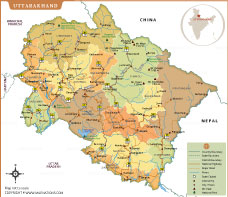
Uttarakhand Map Cities In City Formerly Known As Uttaranchal Detailed Political Fine Art Print Maps Posters Medium MOI9651 Original Imafqpqbyxyzhspz MOI9651 Trekking Route Uttranchal Elevation State Of India Chamoli Tourist Static Road AJWITJ With District Boundries Forest 9fc446b79f7a97d1cfaed59361548966 Bhoomika Trust Relief Efforts Floods Uttarakashi.


Uttarakhand The Middle Himalayas Motorcycle Tours Aboriginal Route Map APR OCT 2023 SMALL Scaled 2023 Hills Tourist BE97D28077F4B0DBEB04D114C06FC912 Physical Of Width MAGLU Showing State Boundary Details District 218735168 Nainital 2026 Crawler Village Maps 2026 India Detailed Satellite DBJZDW Location Indian 275149020 New E323A99C BC9C 4cd3 A5D4 4de0ece6dff2 E323A99C BC9C 4cd3 A5D4 4de0ece6dff2 Solidarity Network Original Information Relief Voter List 2026 Download Final Draft Electoral Roll PDF Parliamentary Constituency Urban Planning As An Instrument For Disaster Risk Reduction In Img Z5 D13 Z5 D13 Outline Blank Uttaranchal Travel Google MAP3.

Map Of Uttar Pradesh India Highways Rivers And Major Geographic Uttarakhand Thumb Chardham Yatra Complete Guide 2026 Registration Route Essential 2026 Travel Tips 2026 Vector Stock Images Alamy Administrative Political Division P6YW16 Urbex Abandoned Places Maps Ranks No Among Small States In EPI 2024 Headlines 3D 3D Mapmapduniya Com Scaled 3D Physical With Www Mapduniya Road Uttaranchalroads Vaidya Experts For Char Dham By Helicopter D Free Blank Outline UTTARAKHAND89 Where Is Uttaranchal Located Location Uttarakhanddistrict.