What is the easiest topographic map generator for beginners?
For beginners in the U.S., online tools like CalTopo or the basic functionalities of AllTrails can be very user-friendly. They offer intuitive interfaces for selecting areas, setting basic parameters, and viewing contour lines. Many provide pre-loaded base maps and easy export options, making them ideal for quick map generation without needing extensive technical knowledge. Look for platforms with clear tutorials.
Are there free topographic map generators available for the U.S.?
Yes, several free topographic map generators and data sources are available for U.S. users. The U.S. Geological Survey (USGS) offers extensive public data and a map viewer. Additionally, platforms like CalTopo have robust free tiers, and open-source GIS software like QGIS allows advanced free customization once you learn the interface. These are excellent starting points for cost-effective mapping.
How accurate are online topographic map generators?
The accuracy of online topographic map generators largely depends on their data source. Generators utilizing high-resolution Digital Elevation Models (DEMs) from reputable sources like the USGS (often derived from LiDAR or high-quality aerial surveys) are generally very accurate for U.S. locations. However, accuracy can vary based on terrain complexity, data age, and the specific resolution of the chosen DEM. Always check the source information.
Can I use a topographic map generator for hiking trail planning?
Absolutely. Topographic map generators are extremely valuable for hiking trail planning. They allow you to visualize elevation changes, assess trail difficulty, identify potential water sources, and pinpoint safe camping spots. You can plot routes, measure distances, and understand terrain steepness, which is crucial for safety and effective navigation in U.S. wilderness areas. Many generators can export to GPS devices.
What are the essential features of a good topographic map generator?
A good topographic map generator should offer accurate, up-to-date elevation data, customizable contour intervals, and the ability to add various map layers like roads and trails. Key features include easy area selection, diverse export formats (PDF, GPX), shaded relief options, and a user-friendly interface. For U.S. specific use, integration with USGS data and local map types is highly beneficial for comprehensive planning.
topographic map generator, generate custom topo maps, online contour map tool, free elevation map generator, create topographic map online, digital terrain map maker, how to get topo maps, U.S. topographic data, best topo map software, custom elevation profileDiscover the essential guide to a topographic map generator, a powerful tool for anyone needing detailed terrain information across the U.S. This comprehensive resource explains what these generators are, how they function, and why they are indispensable for a variety of applications from outdoor recreation to professional planning. Learn about the best online options available, including free and paid services, and compare their features to find the perfect fit for your projects. We provide clear instructions on generating custom topographic maps, understanding contour lines, and leveraging these maps for hiking, land surveying, construction, or emergency preparedness. Understand how to interpret elevation data, identify key geographical features, and plan your routes with precision. This guide helps U.S. searchers make informed decisions on which generator to use, where to find them, and how to maximize their benefits. Explore current trends in digital mapping and enhance your ability to navigate and plan effectively with the latest topographic tools available in 2026.
- What is a contour line on a topographic map? - A contour line on a topographic map connects points of equal elevation above a given reference point, usually sea level. These lines visually represent the shape and slope of the terrain. Closely spaced lines indicate steep slopes, while widely spaced lines suggest flatter areas, providing crucial insights into the landscape's topography.
- Can I create a 3D topographic map with an online generator? - While most online topographic map generators primarily produce 2D maps with contour lines, many offer shaded relief features that simulate a 3D effect. Some advanced platforms or specialized software can indeed render true 3D models or allow export to tools like Google Earth for a more immersive three-dimensional visualization of the terrain.
- What kind of data do topographic map generators use? - Topographic map generators primarily use Digital Elevation Models DEMs, which are grid-based representations of surface elevation. These DEMs are derived from various sources, including satellite imagery, aerial photography, LiDAR light detection and ranging, and traditional land surveys. Reputable generators for U.S. areas often source data from the USGS.
- How often are topographic maps updated in the U.S.? - Topographic maps and the underlying elevation data in the U.S. are updated periodically, but not on a fixed schedule. The USGS continuously acquires new data, particularly through programs like 3DEP 3D Elevation Program, which aims to provide high-resolution data for the entire country. Digital updates are more frequent than traditional paper map revisions.
- Can I download topographic maps for offline use? - Yes, many topographic map generators and mapping apps allow users to download generated maps or base layers for offline use. This feature is particularly valuable for outdoor activities in remote U.S. areas where internet connectivity is unreliable or nonexistent. Common download formats include PDF, GPX for GPS, or specific app-compatible formats.
- Are there mobile apps for generating topographic maps? - Yes, several mobile apps function as topographic map generators or viewers, offering on-the-go access to terrain data. Apps like Gaia GPS, AllTrails, and CalTopo provide robust mapping features, including offline map downloads, route planning, and real-time GPS tracking. They are popular among U.S. outdoor enthusiasts for their convenience and detailed mapping capabilities.
- What is the difference between a topographic map and a road map? - A topographic map primarily focuses on showing elevation and terrain features using contour lines, alongside natural and some man-made features. A road map, conversely, emphasizes transportation networks like roads, highways, and points of interest, with less detail on landforms. Both serve different navigational and informational purposes, though some topo maps include roads.
A topographic map generator is an invaluable digital resource that empowers users to create detailed maps illustrating the terrain and elevation of a specific geographic area. These advanced tools transform raw elevation data into visual representations, featuring contour lines that denote changes in altitude, making them essential for a wide range of activities. From planning your next hiking adventure in a U.S. national park to conducting preliminary site assessments for construction projects, understanding and utilizing a topographic map generator can significantly enhance accuracy and safety.
For U.S. residents and professionals, the ability to quickly access and customize topographic data is crucial. Whether you are an avid outdoors enthusiast, a land surveyor, an urban planner, or simply curious about the landscape around you, a reliable topographic map generator provides the insights you need. This guide will walk you through the functionalities, benefits, and best practices for using these generators effectively, ensuring you can harness their full potential for any project in 2026.
We will delve into various aspects, from how these generators work to identifying the top platforms and understanding key features. By the end of this article, you will be equipped with the knowledge to select and operate a topographic map generator that meets your specific requirements, helping you navigate complex terrains and make informed decisions.
What Is a Topographic Map Generator and Why Use One?
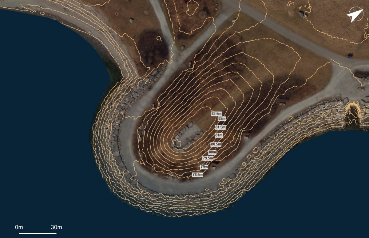
A topographic map generator is a software application or online service designed to create topographic maps based on elevation data. These maps display the three-dimensional features of the earth's surface on a two-dimensional plane, primarily through contour lines. Each contour line connects points of equal elevation, providing a clear visual representation of hills, valleys, slopes, and flat areas. The closer the contour lines, the steeper the terrain, and vice versa.
The primary reason to use a topographic map generator is for its unparalleled ability to provide detailed elevation information that traditional flat maps cannot. This level of detail is critical for route planning in mountainous regions, assessing flood risks, determining optimal locations for infrastructure, or simply understanding the lay of the land. For U.S. searchers, these tools offer access to vast datasets covering diverse landscapes from coast to coast.
Furthermore, these generators often allow for customization, enabling users to add specific data layers, change map styles, or define custom areas of interest. This adaptability makes them superior to static maps, as they can be tailored to the exact needs of a project or expedition, offering dynamic insights into terrain features and potential challenges.
Understanding the Core Functionality of Topographic Map Tools
At its heart, a topographic map generator processes digital elevation models (DEMs). These DEMs are essentially grids of elevation values for specific points on the Earth's surface, often derived from satellite imagery, aerial photography, or LiDAR scanning. When you select an area, the generator retrieves the relevant DEM data.
The software then interprets this data to draw contour lines at predetermined elevation intervals. Users can often specify these intervals, allowing for more or less detailed maps depending on their requirements. Advanced generators may also include features like shading to represent relief, adding color scales for elevation, and incorporating other map elements such as roads, rivers, and points of interest.
Many online generators leverage publicly available datasets from agencies like the U.S. Geological Survey (USGS), ensuring high accuracy and reliability for maps within the United States. This access to authoritative data makes these tools a trusted resource for both professional and recreational use.
How To Generate Your Own Custom Topographic Map?
Generating your own custom topographic map typically involves a few straightforward steps, regardless of the specific generator you choose. The general process often begins with selecting your area of interest, followed by customizing the map's appearance and then exporting or printing your final product. This hands-on approach allows for highly personalized and relevant maps.
Step 1 Select Your Area of Interest
Most online topographic map generators provide a user-friendly interface, often a global map, where you can zoom in and pan to your desired location. You might use a search bar to find a specific address, city, or landmark, or simply drag and drop the map to the target area. Once the area is visible, you will typically use a drawing tool to define the boundaries of your custom map. This could involve drawing a rectangle, a polygon, or defining a specific radius around a point.
For U.S. searchers, many generators integrate with popular mapping services, making it easy to pinpoint locations across all fifty states, including remote wilderness areas or specific urban districts. Verify that the generator covers your desired region and offers sufficient detail for your intended use.
Consider the scale and extent of your map carefully. Generating a very large area might take longer and produce a less detailed map if the resolution is limited, while a smaller, focused area will yield more granular information, ideal for specific trail planning or property analysis.
Step 2 Customize Map Settings and Data Layers
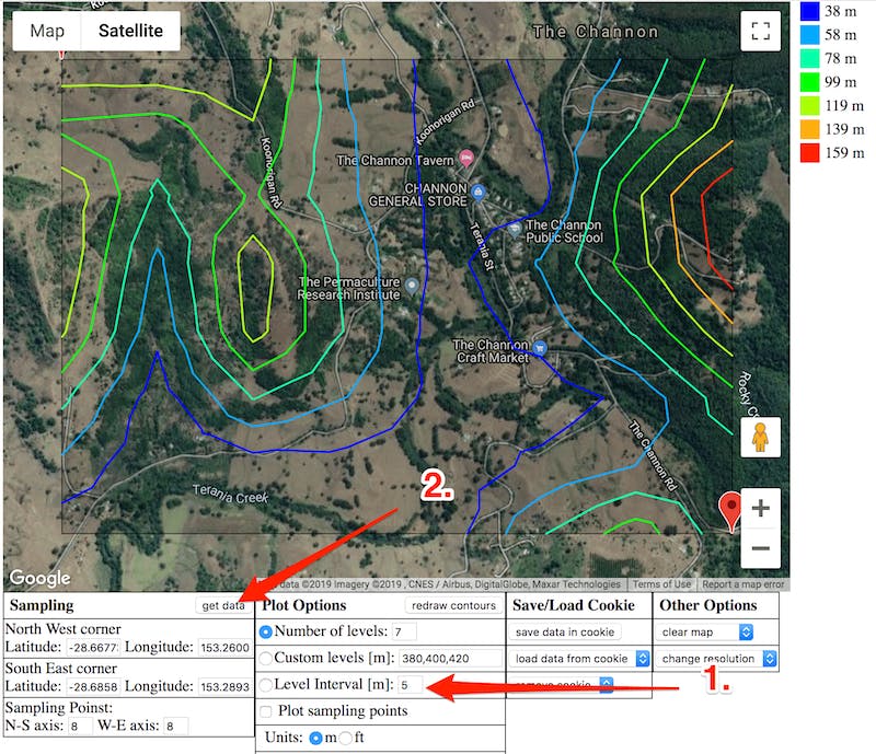
After defining your area, the next crucial step is to customize the map settings. This often includes specifying the contour interval, which determines how frequently contour lines appear. For example, a 20-foot interval will show lines every 20 feet of elevation change, offering less detail than a 5-foot interval. Choose an interval appropriate for the terrain and your specific needs.
Many generators also allow you to overlay additional data. This could include adding roads, trails, bodies of water, buildings, administrative boundaries, or even satellite imagery. Some advanced tools let you adjust color schemes for elevation, add shaded relief for better visualization of slopes, or include grids and coordinates. Experiment with these options to create a map that is both informative and visually appealing. Ensuring your map includes relevant U.S. specific data layers can be very beneficial.
For transactional purposes, some generators offer premium features like higher resolution data, specialized overlays for geology or land use, or the ability to import/export in various file formats. Evaluate if these paid features are necessary for your project before proceeding.
Step 3 Generate and Export Your Topographic Map
Once you have configured all your settings, you can initiate the generation process. Depending on the complexity and size of your map, this might take a few seconds to several minutes. The generator will then render your custom topographic map directly within the application or provide a preview.
Most generators offer various export options. Common formats include PDF for printing, JPEG or PNG for image use, and sometimes KML/KMZ for integration with Google Earth or GIS software, or GPX for GPS devices. Choose the format that best suits how you intend to use your map. Before finalizing, always review the generated map for accuracy, clarity, and completeness, making sure all necessary details are present and legible. You can often save your map for future reference or share it with others.
Where Can I Find the Best Online Topographic Map Generators?
The landscape of online topographic map generators is diverse, with options ranging from free, open-source tools to subscription-based professional platforms. Identifying the best one depends largely on your specific needs, budget, and desired level of detail and customization. U.S. users have several excellent choices, many of which leverage public data for accuracy.
Popular Free and Paid Topographic Map Generator Options
For those seeking free options, platforms like the USGS National Map Viewer are invaluable. The U.S. Geological Survey (USGS) provides a wealth of topographic data and map generation capabilities, offering access to their extensive collection of historical and current topographic maps. While not a 'generator' in the interactive sense for drawing custom lines, it provides the foundational data and pre-generated maps that many other tools build upon.
Another popular choice for free custom map generation is CalTopo. While it offers premium features, its free tier provides robust tools for creating custom topographic maps, including multiple base map layers and route planning capabilities, making it a favorite among U.S. hikers and backcountry enthusiasts. Similarly, programs like QGIS, a powerful open-source Geographic Information System, can be used as a topographic map generator for those with more advanced technical skills, allowing for intricate data manipulation and visualization.
On the paid side, services like Gaia GPS and ArcGIS Online provide more comprehensive features, higher resolution data, and advanced analytical tools. These platforms are often preferred by professionals in land management, environmental consulting, and emergency services who require precise, reliable, and continuously updated topographic information. When considering a paid option, always check reviews, compare features, and look for free trials to ensure it meets your specific project demands.
Why Is Topographic Mapping Important for U.S. Outdoors and Planning?
Topographic mapping holds immense importance for various sectors across the United States, particularly for outdoor recreation and critical urban and rural planning initiatives. Its detailed depiction of elevation and landforms provides essential context that flat maps simply cannot, making it a foundational element for informed decision-making and safety.
Enhancing Safety and Navigation for Outdoor Enthusiasts
For U.S. outdoor enthusiasts, including hikers, backpackers, mountain bikers, and climbers, topographic maps are indispensable for safety and effective navigation. They reveal critical details about terrain steepness, potential hazards like cliffs or ravines, and the most efficient routes. Understanding contour lines allows adventurers to anticipate ascents and descents, manage energy levels, and avoid dangerous areas, especially in remote or unmarked trails within national forests or state parks.
Many searchers use topographic map generators to plan multi-day excursions, locate water sources, identify suitable camping spots, and determine bailout routes in case of emergencies. The ability to generate and carry a custom topographic map, either digitally on a GPS device or as a printed copy, provides a crucial layer of preparedness that can make the difference between a successful outing and a perilous situation. Integrating GPS coordinates from these maps with a physical compass further enhances navigational accuracy.
Crucial for Urban Development and Environmental Assessment
Beyond recreation, topographic mapping plays a vital role in urban development, land management, and environmental assessment throughout the U.S. City planners, engineers, and architects rely on detailed elevation data to design infrastructure, plan new communities, and mitigate risks. For instance, understanding a site's topography is fundamental for effective stormwater management, preventing erosion, and ensuring proper drainage for buildings and roads.
Environmental scientists and conservationists use topographic maps to study watersheds, analyze habitat connectivity, and assess the impact of climate change on specific landscapes. They are crucial for flood plain mapping and determining areas vulnerable to natural disasters. Local U.S. government agencies often require topographic surveys for zoning permits and environmental impact statements, making accurate map generation tools essential for compliance and responsible development.
What Users Should Know Before Taking Action
Before diving into using a topographic map generator, there are several key considerations that U.S. users should keep in mind to ensure the best results and avoid common pitfalls. Being prepared with this knowledge will help you choose the right tool and create maps that truly meet your needs.
Consider Data Source and Accuracy
The reliability of your generated topographic map is directly linked to the quality and source of the elevation data it uses. For U.S. locations, ensure the generator utilizes reputable data sources such as the U.S. Geological Survey (USGS) or National Oceanic and Atmospheric Administration (NOAA) for coastal areas. These government agencies provide high-resolution and regularly updated digital elevation models (DEMs).
Be aware that free or less sophisticated generators might use lower-resolution data, which could result in less accurate contour lines, especially in areas with subtle elevation changes. If your project requires high precision, such as for surveying or engineering, investing in a generator that uses advanced LiDAR data or very high-resolution DEMs is advisable. Always verify the date of the data collection if possible, as landscapes can change over time.
Understand Map Projections and Coordinate Systems
Topographic maps inherently involve projecting a three-dimensional Earth onto a two-dimensional surface, which always introduces some distortion. Understanding map projections (e.g., Universal Transverse Mercator UTM, Lambert Conformal Conic) and coordinate systems (e.g., latitude/longitude, State Plane Coordinate System) is crucial for accurate measurement and integration with other geospatial data. Most generators will handle these automatically, but knowing which projection and coordinate system your map uses is vital if you plan to combine it with GPS data or other maps.
For U.S. specific applications, many professional uses will default to UTM or a relevant State Plane zone. Familiarize yourself with these concepts, especially if your work requires precise spatial analysis or field navigation where small errors can have significant consequences. Ensure your chosen generator allows you to specify or at least understand the projection of the output map.
Conclusion Navigating Your Next Steps with Topographic Maps
A topographic map generator is an indispensable tool for anyone in the U.S. seeking detailed insights into terrain and elevation. Whether you are planning an outdoor adventure, conducting professional surveys, or engaging in urban development, the ability to create custom, accurate topographic maps is invaluable. By understanding what these generators are, how they work, and what features to prioritize, you can confidently select the best tool for your specific needs.
We encourage you to explore the various online and software options available, starting with free resources like those offered by the USGS or the basic functionalities of platforms like CalTopo. Compare their features, test their interfaces, and consider reviews from other U.S. users to find a solution that aligns with your project requirements and budget. Remember to always prioritize data accuracy and understand the fundamental mapping principles involved.
With a well-generated topographic map in hand, you are better equipped to make informed decisions, enhance safety in the wilderness, and contribute to responsible land use. Take action today to empower your next project or adventure with the precise elevation data you need. Your journey to mastering terrain analysis begins with selecting the right topographic map generator.
best online topographic map generators, how to make a custom topo map, free elevation map creator, understanding contour lines, benefits of digital topo maps, topographic map generator reviews, compare topo map tools, where to find U.S. topographic data, how to use a map generator, cost of topographic mapping software


Create Stunning 3D Maps With Terrain Generator Terrain Map Design . 3D Map Generator Terrain From Heightmap Preview Topographic Map . How To Create A Free Topographic Map For Your Design W 4Gjhbbrmt8 Og. How To Get A Topographic Map Of My Property Free Infoupdate Org How To Create A Free Topographic Map For Your Design FB . 3D Map Generator Terrain From Heightmap Map Generator Isometric


3D Map Generator Atlas From Heightmap To Real 3D Map Preview 3d . How To Create A Free Topographic Map For Your Design ThKkdb8uXTo C54 ChuGUn3eTA HphV3PY Yz7 V. How To Extract Contour Lines From Contour Map Creator Website YouTube . Free Online Elevation Contour Generator March 1 2026 Contour Map . Contour Map Generator Create From Built In US Elevation Data Equator 1200x777



Premium Photo Topographic Map Of A State With Elevation Lines Topographic Map State With Elevation Lines Generative Ai 1169651 9421 . CNC Topographic Map Generator Equator Step 3 . GitHub Procedural Topography Procedural Topographic Topographic Map Feature 1 . Premium AI Image Topographic Height Map Generate Ai Topographic Height Map Generate Ai 98402 6018 . Best Random Topographic Map Generator Vondy Rxur5t



App Create Beautiful Topographic Maps In Seconds Show The Community 2 1024x581 . How I Create Contour Map From Dem In 2026 Topographic Profiles For . A Topographic Hiking Map Showing Elevation Contours Trailheads And Topographic Hiking Map Showing Elevation Contours Trailheads Terrain Features 1314467 191888 . Website Topical Maps Generator . Topographic Map Generator Autocad



Array 0 Tn 1 City A 2 30m St Gmg . Captivating Topographic Map Pattern Generator Showcasing Intricate Captivating Topographic Map Pattern Generator Showcasing Intricate Terrain Designs 994764 179697 . Topographic Map Generator 139de8 . CNC Topographic Map Generator Equator Group 1443 400x227 . Topographic Map Generator Fab Adc169cd F476 4e17 81a6





Best Random Topographic Map Generator Vondy C4g4y9 . 79 Topographic Map Pattern Generator Terrain Designs 79 Topographic Map Pattern Generator Terrain Designs 1314184 6122 . GitHub SuheybAden Topographic Map Generator GitHub Topographic Map Generator. How To Create Your Own Topographic Map 17 Steps With Pictures . Best Topographic Map Generator Vondy Image Proxy



Creating Topographic Maps For Regional Planning Ar Generative Ai Creating Topographic Maps Regional Planning Ar Generative Ai 1198270 121510 . 3D Map Generator Atlas From Heightmap To Real 3D Map 3d Topo Map . Best Of The Week AI Agents Topographic Web Design And Type That Lives. How To Create Your Own Custom Topographic Map Topo Streets 3D Topo Maps . Make Your Own Topographic Map Topographic Map Generator YTBNHW Create A Topographic Map For You